- Home
- Collaborate Now
- Collaboration Center
- Tools for Collaboration
- Mapping, Graphing, & Visualization
Mapping, Graphing & Visualization Tools
 Tool Features:
Graphs and charts are great because they communicate information visually. Graphs can be used to compare data from different locations.
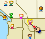
Interactive guest maps can be used to visualize who is participating in your project. The guestmap allows teachers to "thumbtack" each location on a world map. You can customize data questions for details, comments and flag icons. When moused over, the guestmap entry information pops up for all to read. You will be automatically emailed whenever a new participant signs the map. It literally does all the work for you and the visual aspect of the world map highlighting global participants is a great motivator for teachers and students alike.
Where Tool Can Be Found:
Bravenet Guest Maps
- free
http://www.bravenet.com/samples/guestmap.php
Create a Graph
- free
http://nces.ed.gov/nceskids/graphing/
Examples of Tool Implementation for Collaboration:
To see this “cool tool” in action visit DAY I WAS BORN PROJECT by Catherine Campenella